Map comparison baseline
Use this small fixed set when changing POI visibility, map styling, search rows, or place sheets. Compare the same camera, viewport, theme, locale, and dataset. Keep data coverage, provider behavior, cartographic eligibility, and label collision outcomes separate when explaining a difference.
Reference capture: October 6, 2026
The reference is the live OpenMapX.com instance in a 430 × 932 CSS-pixel
viewport, DPR 1, English, light theme, Default map, zero pitch/bearing, and no
optional overlays selected. Browser: T3 Code collaborative preview, Chromium
152.0.7977.130 / Electron 44.4.2, desktop user agent with phone-sized CSS viewport.
It contains 20 maps, four search views, and two
place sheets. The production deployment commit is unknown. Its light/dark style
file hashes match repository commit f4229bbd81282f3fbaaf999eef61f863bcfc63aa;
that establishes the cartography revision, not the entire deployed application.
The machine-readable evidence records camera coordinates, rendered POI names/classes/ranks, road-label counts, screenshots, search text, place URLs/text, enabled integration IDs, registry revision, asset SHA-256 hashes, and public TileJSON metadata. No credentials or private account data were inspected or recorded.
| Source | Observed configuration / version |
|---|---|
| Vector basemap | Self-hosted /tiles/data/openmapx.json, Germany bounds; native maximum zoom 14 |
| OSM input | planetiler:osm:osmosisreplicationtime=2026-10-03T20:20:50Z, sequence 4927 |
| Generator | Planetiler 0.10.2, hash 0e5588c4a6e8c29a270a33afe8df62027d889604 |
| Schema metadata | OpenMapTiles version 3.16.0 |
| Glyphs / sprites | Self-hosted /tiles/fonts; owned /styles/sprite |
| Default relief | Mapterhorn through /api/mapterhorn/tiles.json |
| Search | UI credits MapTiler; chain/category suggestions also appear |
| Integrations | 104 report enabled; this does not establish configured keys, successful requests, or regional coverage |
planetiler:buildtime in TileJSON is March 28, 2026 and predates the OSM input.
Treat it as generator build metadata, not an established date for this tile
archive. An archive checksum/build date and deployment commit are unavailable
from these public responses; record them when doing an operator-controlled run.
Native zoom 14 means maps at zooms 15 to 18 overzoom the same dataset.
Fixed map cases
All cases use zooms 14, 15, 16, 17, 18. Click an image to inspect it at full size. Monschau is a rural tourist town rather than an empty countryside fixture: it exercises useful destinations, narrow streets, and surrounding terrain.
| Case / centre (latitude, longitude) | z14 | z15 | z16 | z17 | z18 |
|---|---|---|---|---|---|
| Berlin Mitte: 52.520407, 13.404914 | Map | Map | Map | Map | Map |
| Aachen old town: 50.7754, 6.0839 | Map | Map | Map | Map | Map |
| Neuss town centre: 51.1982, 6.6916 | Map | Map | Map | Map | Map |
| Monschau: 50.5545, 6.2407 | Map | Map | Map | Map | Map |
Counts below are deduplicated queryRenderedFeatures results from poi-level-1,
poi-level-2, poi-level-3, poi-landmark, and poi-railway, keyed by feature
ID, falling back to serialized name/class/geometry when no ID exists. Business
classes
are restaurant, cafe, bar, beer, bakery, ice_cream, fast_food, shop, grocery,
clothing_store, and alcohol_shop. A count includes canvas features behind UI
panels and partly clipped at the viewport edge; it is not a count of fully
readable labels or an independent ground-truth recall score. Review the images
as well. The geographic footprint shrinks with zoom, so these counts should
not increase monotonically.
| Case | All POIs at z14 / 15 / 16 / 17 / 18 | Business POIs at z14 / 15 / 16 / 17 / 18 |
|---|---|---|
| Berlin | 10 / 11 / 8 / 18 / 9 | 0 / 0 / 5 / 11 / 7 |
| Aachen | 7 / 3 / 7 / 15 / 12 | 0 / 0 / 2 / 6 / 8 |
| Neuss | 4 / 5 / 11 / 8 / 16 | 0 / 0 / 5 / 4 / 13 |
| Monschau | 5 / 5 / 13 / 17 / 10 | 0 / 0 / 5 / 10 / 5 |
At zooms 14 to 15 the initial policy excludes ordinary businesses. At zoom 15, Berlin shows Berlin Cathedral, Berlin Dungeon and Hackescher Markt; Aachen keeps Aachen Cathedral; Monschau shows Burg Monschau and Haller. Businesses appear at closer zooms. This is an eligibility decision, not evidence that the dataset lacks restaurants or shops.
Search and place cases
Search from each fixed centre at zoom 15, without moving the map. Record the complete visible suggestion order and provider credits before selecting a row. These observations describe the October 6 capture; they are not desired rankings or a claim about the current deployment.
| Query / centre | Reference observation | Evidence |
|---|---|---|
| Hauptbahnhof Berlin / Berlin | Berlin area first, then Hauptbahnhof at Europaplatz; another Hauptbahnhof at Wuhlheide also appears | Search |
| REWE / Berlin | Two local places, a chain suggestion, a distant place, and category matches | Search |
| Aachen Dom / Aachen | Domschatzkammer first, then Domsingschule and nearby businesses; cathedral absent from displayed rows | Search |
| Café / Monschau | Category rows and local cafes, plus chain suggestions and a distant airport | Search |
Open Aachen Cathedral by tapping its basemap symbol at zoom 17. The landmark sheet includes a credited Wikimedia photo, address, phone, website, Wikipedia summary, foundation/architect facts, and accessibility information. Search Schloss-Café from Monschau, then select the Stadtstraße 4 to 6 result. The business sheet has address, phone, website, menu/order actions and outdoor seating, without a visible photo. Their different entry paths and content availability are intentional fixture coverage. Exact place deep links are in the evidence JSON.
Place screenshots show the initial half-height sheet, without manual expansion or scrolling. The evidence text also includes rendered DOM content below the screenshot fold; the listed facts are available sheet content, not all visible at once. Repeat the initial sheet state before comparing layout.
For offline search-ranking regressions, use the existing
packages/core/src/utils/__tests__/search-eval fixtures and
pnpm search-eval:record; this visual baseline complements that suite.
Repeat and assess a change
- Record the tested Git SHA and deployment SHA, date, browser version, viewport/DPR, locale, theme, map mode, pitch/bearing and selected overlays. Record vector/glyph/terrain URLs, provider settings, non-secret credential availability, archive checksum/OSM snapshot, and enabled integrations.
- Open
/?map=LAT,LON,ZOOM,0,0for each case. Clear search and close panels. Wait for MapLibreidle, verify style and tiles are loaded, then allow label fades to settle before capturing. A ready check immediately after a camera jump can describe the previous frame; discard blank/loading captures. - Save one image per case/zoom in an external dated archive with evidence JSON. Keep the reference immutable. Compare current and changed styles against the same source tile URLs; a live dataset update invalidates a strict A/B.
- Repeat the four searches and two place entry paths. Record missing provider credentials, failed requests, absent photos and incomplete coverage separately.
- For cartography changes also repeat z14 to 15 in dark theme and a fixed desktop viewport. Assess readable business names, road-name retention, landmark and station prominence, overlapping symbols, clipped names, and duplicate labels. Check z16 to 18 for unintended changes and unnamed/non-ground-level points for leakage.
For the early-POI experiment, success means a restrained selection of named businesses is discoverable at neighborhood zooms, landmarks remain prominent, and the map remains readable. More candidates alone is not success. Tile ranks are local ordering signals, not popularity, review quality, or global fame. Do not infer missing places from a collision-hidden label.
The reference is a visual/discovery baseline, not a performance benchmark, complete German coverage audit, or device certification. Pair performance work with navigation performance measurement.
Neighborhood POI follow-up
This is the October 6, 2026 comparison against the initial reference. Inspect the current policy module before changing its thresholds.
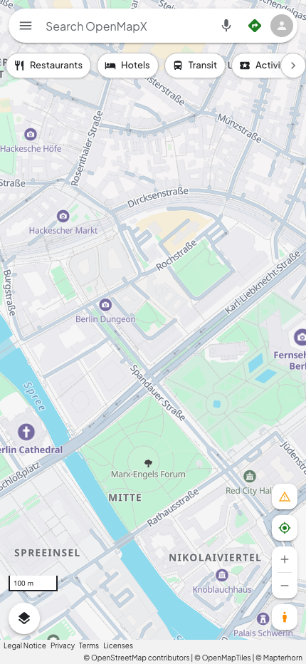
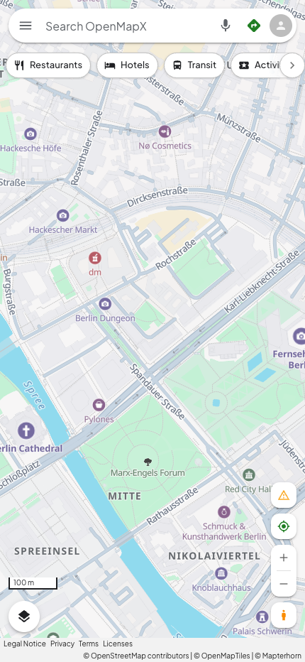
The first change against this baseline introduces named, ground-level food destinations and shops at z14 to 15. The maximum local tile rank is 8 / 24 for restaurant, cafe, bar, beer, bakery and ice_cream, and 4 / 12 for shop, grocery, clothing_store and alcohol_shop. Parking is a separate policy group with its original later introduction. These values do not claim popularity or fame.
poi-neighborhood-business occupies z14 up to, but excluding, z16. It draws
below the existing POI and road-name layers so their labels claim space first.
The regular POI layers exclude these businesses below z16 to avoid duplicates;
their original close-up progression resumes at z16. Unnamed, empty-name,
non-ground-level and unranked candidates are excluded at neighborhood zooms. All symbols
keep collision avoidance enabled.
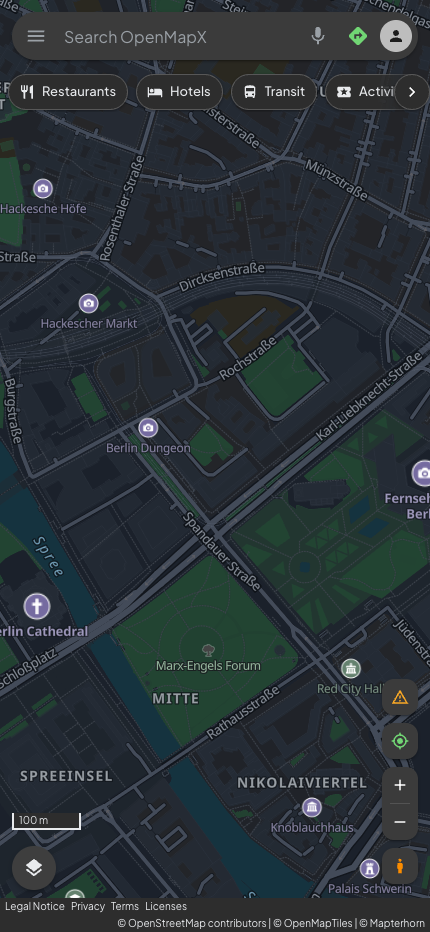
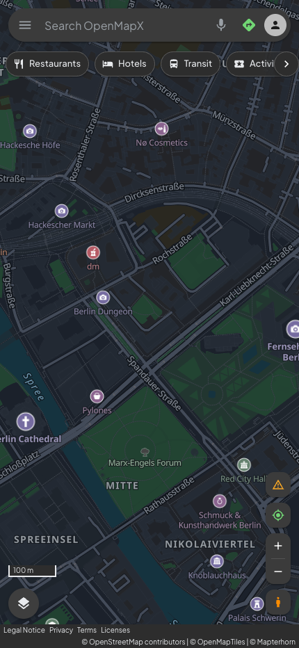
The follow-up evidence includes 20 light maps, eight dark maps, desktop light/dark comparisons and a tap-to-place check. The candidate was applied temporarily in the browser on OpenMapX.com: generated POI filters and the new layer, with the application's existing name localization. The live instance was not deployed or changed. Public TileJSON still reported the same October 3 OSM snapshot/schema; the archive checksum and deployed application SHA remain unknown. These captures isolate the style change against the same live instance and source URLs.
| Case | Business POIs z14: before → after | Business POIs z15: before → after |
|---|---|---|
| Berlin | 0 → 1 | 0 → 7 |
| Aachen | 0 → 1 | 0 → 4 |
| Neuss | 0 → 6 | 0 → 5 |
| Monschau | 0 → 2 | 0 → 1 |
Every baseline POI remained in the 20 light views, road-label counts were unchanged, and z16 to 18 POI results were unchanged. Dark views matched the light POI counts. The lower priority matters: an initial trial in the ordinary POI layers displaced three smaller Berlin cultural labels; the final layer avoids that in these fixtures. This is observed fixture coverage, not a guarantee for every provider or city. Source rank alone also cannot promise that the most useful restaurant or café is the one labeled in each neighborhood.
| Berlin z15 before | Berlin z15 after |
|---|---|
 |  |
| Dark before | Dark after |
|---|---|
 |  |
Maintain the policy in apps/web/scripts/poi-visibility-policy.mjs and its layer
generation in apps/web/scripts/apply-poi-visibility.mjs; run
pnpm -C apps/web style:poi to regenerate both owned styles. Do not edit just
one generated style. scripts/__tests__/poi-visibility.test.ts uses MapLibre's
installed expression engine against both generated styles to check eligibility,
rank boundaries, exclusions, duplicate prevention, layer priority, and validity.
Repeat generation to check idempotence and repeat the visual matrix before
expanding the thresholds. Hosted complete MapTiler styles are outside this
owned-style policy.
For versioned search, identity, enrichment and navigation evidence alongside these visual cases, follow Discovery evaluation. Store new capture archives externally with a manifest and checksums; attach selected review images directly to the PR.
Regional ambient-place acceptance (#399)
The October 8 to 9 acceptance run repeats the four fixed cameras at zooms 14 to 18 against the same public basemap TileJSON and the same policy-2 regional publication. Neuss lies inside the published Rhine bbox; Berlin, Aachen and Monschau are outside-region controls. Cologne and a rural Rhine camera add dense/sparse positive cases. This is a disposable real OSM extract, not a production deployment or a recall audit of all German places.
Source eligibility and rendered labels remain separate: Quirinus-Münster has corroborated source-backed zoom-14 eligibility, while retained city/road labels can still win a particular collision. The fixed zoom-16 Neuss view gains its name with collision-safe landmark anchors. Ordinary labels keep one position. All 45 paired views compare source/source-layer/feature-ID, rendered-layer, coordinate/name identities as well as road-name lists. Known owned basemap identities and selected/category destinations suppress their ambient counterpart; distinct source IDs are not guessed to be the same business merely because their names are similar.
See regional publication and measured budgets
and its aggregate JSON for source hashes, fixed settings, camera outcomes,
read/fallback/rollback evidence and desktop/Safari simulator frame samples.
The October 9 cartographic correction borrows the active basemap's POI badges,
category colors, typography and halos, replacing the separate teal dot/label
renderer. Ordinary names sit below their badges; landmark names use compact
wrapping. The icon and text must fit together; both retain normal collision
checks. The new matrix, runtime and screenshots are recorded
separately under visualCartographyFollowup in the aggregate artifact.
Before/after screenshots are PR attachments outside git. Simulated Safari results
must not be presented as physical-device battery, thermal or fleet certification.